We want to start by thanking each of the approximately 60 attendees who impressively listened so carefully throughout the whole meeting and asked questions at the end.
The meeting was opened by Dean Metzger, Chair of Berkeley Neighborhoods Council. He welcomed all the attendees and made special mention of Martha Nicoloff who was the co-author of the original Neighborhood Preservation Ordinance (NPO). Martha could not attend the Forum today because of health problems, but BNC wanted to acknowledge the special contribution she made some 40 years ago in getting the NPO initiative approved by the voters.
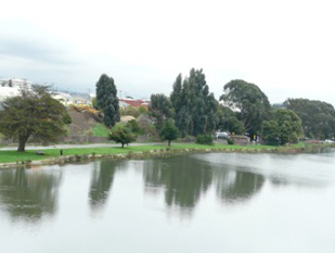
Moderator Steve Finacom, former President Berkeley Historical Society and member of the Le Conte Neighborhood Association opened the session by outlining some of the long activist history of his neighborhood, adjacent to where the Forum was held.
In the early 20th century the Southern Pacific Railroad moved its freight yards from Downtown to where Berkeley Bowl and Walgreens are today. In the 1920s, Le Conte residents protested those freight yards next to their residential area and the property was later sold for commercial development. Decades later a new generation of residents agitated against a city economic development proposal that would have settled for a chain discount store on the block, to replace a closed Safeway; instead, the highly popular, since expanded, Berkeley Bowl store came about.
In the 50s and 60s, residents all along Ashby successfully raised the alarm about State plans to turn Ashby Avenue (State Highway 13) into a freeway that would have obliterated much of South Berkeley. That proposal was stopped. In the 1970s, Le Conte residents were leaders in getting the City to implement a comprehensive Traffic Management Plan that shifted commuter cars off neighborhood streets. These efforts included walk-in protests at intersections and years of meetings. As a result the traffic-chocked one-way Fulton Freeway and Ellsworth Street became livable neighborhood streets again. In the 1990s, Le Conte was a leader in getting traffic circles in residential districts.
Le Conte residents were also active in the 1970s in obtaining voter approval of the Neighborhood Preservation Ordinance that stopped the unchecked demolition of older homes for cheaply built apartment buildings. The neighborhood Victorians, brown shingles, bungalows, and classic boxes once regarded by developers as throw-away structures remain today as cherished and highly-sought after family homes. Ironically, many of the buildings the developers did succeed in building in the 60s and 70s are unsafe soft story structures in need of earthquake retrofit.
In sum, much of the history and character of the District and other Berkeley flatlands neighborhoods comes not from top down City plans, but from the activism of residents who felt their neighborhood should be preserved and improved as good places to live, not turned into sites for the latest trendy and, later, discarded forms of development.
David Shiver spoke of density from the perspective of the professional analytic work he does with other communities. Density is many things to many people. For Planners: Density means “standards” — people per acre, number of employees per 1,000 square feet, auto/truck trips per use. For Developers: Density means “economic viability” — a factor in construction costs and project feasibility, the more units and/or square feet, the more potential profit. For Residents: Density means “impacts” — higher levels of traffic, changes in neighborhood character, physical impacts such as loss of light, more noise, etc.
Density is affected by:
- local zoning decisions — Planning Commission, Zoning Adjustments Board and City Council;
- regional decisions — the Association of Bay Area Governments (ABAG) that forecasts growth and allocates housing needs goals for each city and county in the East Bay;
- State laws that set requirements for General Plans and Housing Elements, requires certain projects be subject to the California Environmental Quality Act (CEQA), requires incentives (usually an extra floor) be given to developers who meet certain requirements through the State Density Bonus Law, the Housing Accountability Act, and SB 375 which seeks to reduce greenhouse gases and promote sustainable communities through concentration of development in locally-designated Priority Development Areas (PDAs).
ABAG forecasts growth for Berkeley through the One Bay Area Plan, as follows:
| 2015 | 2040 | Change | |
| Population | 116,600 | 140,100 | 23,500 |
| Housholds | 47,660 | 54,290 | 6,630 |
| Employed Residents | 53,700 | 62,370 | 8,670 |
| Total Jobs | 83,130 | 99,330 | 17,200 |
ABAG’s Regional Housing Needs Plan and Allocation (RHNA) for Berkeley include:
| 2014 to 2020 | ||||
| Total | Very Low | Low | Moderate | Above Moderate |
| 2,959 | 532 | 442 | 584 | 1,401 |
These charts indicate that between now and 2020 (6-years), Berkeley will have:
- 23,000 more population
- 6,600 more households
- 2,900 more housing units (1400 of which will be market rate or above)
This development will mostly occur in locally designated Priority Development Areas (PDAs), the largest of which is the Downtown (4,150 housing units), 4 others with housing units between 250 to 550, and 1 with 870 housing units (San Pablo Avenue).
| Housing Units | Households | |||||||
| 2010 | 2040 | Growth | 2010 | 2040 | Growth | |||
| 49,950 | 52,740 | 9,280 | 19% | 46,030 | 55,980 | 9,950 | 22% | |
| Adeline Street | 690 | 940 | 250 | 620 | 900 | 280 | ||
| Downtown | 2,690 | 6,840 | 4,150 | 2,570 | 6,670 | 4,100 | ||
| San Pablo Ave | 1,630 | 2,500 | 870 | 1,440 | 3,340 | 900 | ||
| South Shattuck | 340 | 460 | 110 | 310 | 440 | 120 | ||
| Telegraph Ave | 1,100 | 1,470 | 350 | 390 | 1,400 | 410 | ||
| University Ave | 1,480 | 2,030 | 550 | 1,390 | 1,940 | 550 | ||
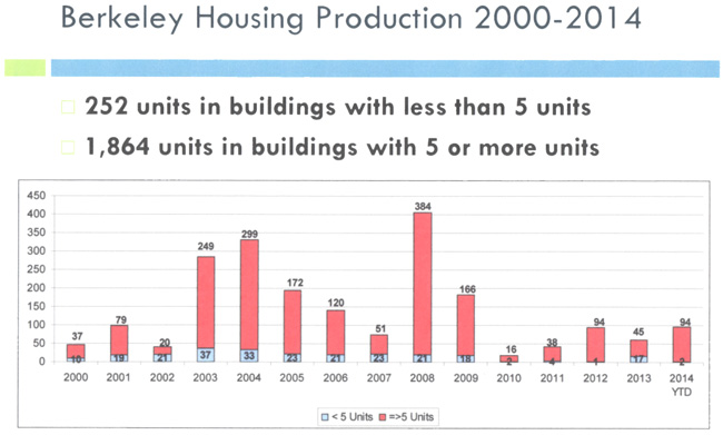
How has Berkeley been doing? Since 2000 there has been a “boom or bust” type pattern of housing development, reflecting national and Bay Area economic cycles.
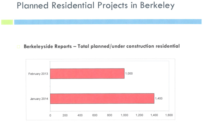
According to Berkeleyside, planned residential projects in Berkeley indicate there were 1,000 residential projects planned or under construction in February 2013. In January 2014 that number had jumped to 1,400.
What are the density issues in Berkeley? Our General Plan (aka Master Plan plus various Area Plans) indicates a density of up to 22 people per acre for R-1 Districts, 22-44 people per acre for R1A and R-2 Districts, and 44-88 people per acre in R-2A and R-3 Districts. Certain projects, like Mini-Dorms, that have been approved by the City result in densities more like 180-260 people per acre.
Zoning ordinances must be consistent with the general plan (Cal.Gov’t Code §65860) in general law cities. However, Berkeley is a charter city. In charter cities, zoning ordinances are not required to be consistent with their general plan unless the city has such a requirement in their charter or adopted a consistency requirement by ordinance (Cal.Gov’t Code §65803). Berkeley does not have such a consistency requirement so zoning decisions regarding conformity to our General Plan are discretionary.
While many cities calculate density on a parcel basis, Berkeley’s General Plan explicitly states that density calculations are “not parcel based.” Berkeley doesn’t have density standards in our Zoning Ordinance. What can happen is that as one density increases in one area, it results in pressure to increase density in adjacent areas — “density creep.”
There are 4 things to consider for action:
- Enact a Consistency Ordinance:The Zoning Ordinance should conform to the General Plan. Considerable city and citizen resources and time is spent on planning issues.
- Amend the General PlanRequire that density calculations be parcel based. This will ensure objective measurements of the proposed project density. This is a fairly typical planning practice.
- Strengthen Historic PreservationPromote historic property designations on the State Registry. Encourage residential historic districts. Develop design standards for properties near historic properties.
- Adopt Design StandardsProvide for consistent treatment along all of Berkeley’s transit corridors. Ensure sensitive transitions from higher-densities on major arterials at interfaces with R1-R3 residential districts. Berkeley has such a standard for University Avenue but not other areas in the City. This also is a very typical planning standard.
![]()
If these measures are adopted, there will be less potential for conflict, more certainty in what can be done or not done in new development projects. All parties would benefit: City planners, elected officials, citizens, neighbors and developers.
Architect and Berkeley Planning Commissioner Patrick Sheahan speaking on Access to Sun Energy and Open Space started by saying: I would like to speak about open space, as that which provides light, air, view, privacy, and sunlight (including passive and active solar) in both the public and private realms. Planning and Zoning for open space, and to protect existing open space, is essential to maintain quality of life as cities grow and population density increases. Planning and Zoning must encourage growth in an organic sense; ensuring that growth occurs in a manner which is consistent with the scale, use and pattern of development, such that new growth does not deprive neighboring properties of open space and is consistent with the prevailing pattern of development.
Pictures of some recently proposed, constructed and approved developments in Berkeley are worth a 1,000 words.
Solar
A core goal of Berkeley’s Climate Action Plan is to reduce consumption of non-renewable sources of energy. Yet, the mechanisms that encourage solar installation in Berkeley are weak and inefficient.
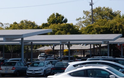
The photovoltaic car shelters at Bayer Laboratory’s parking lot (NE corner Dwight Way and 7th) is the largest solar installation in Berkeley. In addition to generating renewable energy, the location covering a large area of parking also reduces the heat island effect by absorbing sunlight converted to energy rather than absorbed by asphalt paving and radiating heat.
Solar installations depend on access to solar, and development should be planned to encourage solar installations on rooftops of commercial and residential buildings.
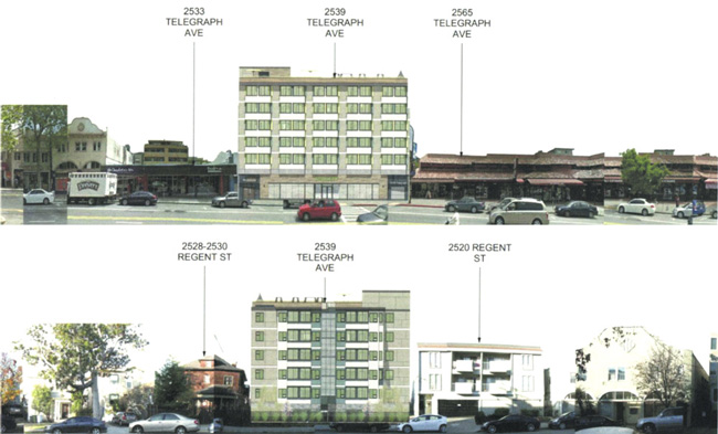
2539 Telegraph Avenue (Old Center for Independent Living Building)
A proposed new development at 2539 Telegraph (between Dwight Way and Parker) violates the principal of equitable access to open space. A building that is six stories, 65 feet high, is proposed where the pattern of development is 2-3 stories and adjacent properties are zoned for 35 foot height. At the urging of the developer, Patrick Kennedy, and other Telegraph Avenue commercial property owners, the Floor Area Ratio was recently raised by the City Council to allow for increasing the density on Telegraph Avenue from Bancroft to Parker without notification to adjacent residential property owners who would be impacted. The only accessible open space for residents of the project is a small area of the rooftop exposed to the elements, and no private open space is provided. Also, this project extends in the rear toward residentially zoned Regent Street where it will decrease the size of an existing small park and tower over existing single family homes.
The following are 4, some approved and some potential, examples of piecemeal zoning that is now being used to replace existing West Berkeley comprehensive planning that considers open space, views, light, privacy and solar access issues and consistency with the scale, use and pattern of prevailing development.
740 Heinz
In 2009, the developer, Wareham, requested a Variance from the Zoning Ordinance to construct a lab building that would be 75 feet high where only 45 feet is allowed. In exchange for the Variance, the developer proposed preserving the historic north and south walls of the Copra Building, a designated Berkeley landmark. That Variance was approved. In 2012, the developer submitted a changed application requesting a Variance to build that 75 foot high lab building but instead of preserving the landmark, the historic Copra Building would be demolished. That Variance was granted and an appeal by a group of citizens of that decision was made to the City Council. The appeal was dismissed and the variance approved by the City Council before the outcome of Measure T was decided. Measure T was proposed by the Mayor and Council and placed on the ballot. Measure T would allow development of buildings 75 feet high where 45 feet was allowed in the West Berkeley Plan. In the election of November 2012, the voters of Berkeley rejected Measure T. An appeal of the Variance decision has been filed with Superior Court.
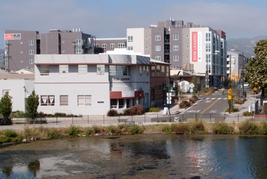
The Archstone Building
The Archstone, bounded by University, Addison, Third and Second Streets is in West Berkeley, but in a different zoning classification (C-W) than the 740 Heinz building. The Archstone is nominally 60 feet high, having been granted a density bonus in exchange for reserving 14 of its 94 residential units for low income households. This density bonus added 10 feet to its 50 foot allowed height. However, 60 feet is the height of the roof, whereas the building code measures height to the top of the parapet. In the case of the Archstone, the parapet extends to 70 feet high to partially enclose rooftop open space and the City allowed the buildings “archtecural features” and mechanical penthouse to increase the height to 82 feet.
Peerless Greens
The Peerless Greens project in West Berkeley is owned by Doug Herst. It is bounded by Third Street (the railroad tracks) on the west, Fifth Street on the east, between Bancroft Way and Allston Way. Mr. Herst was a major proponent of Measure T which would have enabled this project to be 75 feet high where 45 feet was allowed. Following the defeat of Measure T, Mr. Herst has been in closed-door discussions with Berkeley Planning and Development staff to rezone this area to a C-W classification, the zone which allows mixed-use projects the scale of the new Archstone Building.
Aquatic Park
The owners of the properties immediately south of the Archstone building, that run along the eastern edge of the road (Bolivar Drive) that parallels the edge of Aquatic Park from Addison to Channing, may be planning to apply for rezoning to C-W which would allow buildings the scale of Archstone, dominating Aquatic Park and obscuring views of the Berkeley Hills. Looking at the photo, imagine 75 foot buildings in this location and their impact on Aquatic Park.
The Future of Planning
The city of Berkeley appears to have abandoned comprehensive planning, which involves extensive open and public process in favor of a piecemeal approach by enacting rezoning favorable to developers, overlooking regulations and granting variances and excessive density bonuses. The realized and planned projects that have been enabled by this approach take open space inequitably, impacting views, light, privacy and solar access, from the public and private realms and diminishing the quality of life for all.
Next, Sophie Hahn, who has served on the Zoning Adjustments Board for several years, spoke on the issue of Detriment.
Zoning is a social contract we all make with each other, preserve the neighborhoods and community we collectively agree we want to live in. Each property owner or resident gives up certain rights in exchange for others also giving up rights (like the “right” to build as many units or as much height as you might want on your parcel). To honor that mutual commitment, the Code must be applied in a fair and even-handed manner. The Zoning Ordinance also embodies the vision for the City as expressed in the General Plan and in the various Area Plans and Overlays which have been adopted. The Code is the set of laws and regulations which translate the Plan into enforceable measures.
For a project which requires a Use Permit (“UP” — generally granted by the Zoning Adjustments Board (ZAB) or an Administrative Use Permit (“AUP” — generally granted by Planning Staff) to be approved, it must do three things. First, it must conform to the specifications of the Code as to height, lot coverage, uses, parking, and a variety of other elements applicable to the specific project and site. Second, if there are additional “findings” specified in the Code, those findings must be made. One example of a specific finding might be that the Code allows for a set-back to be adjusted from the normal requirement only if it does not unduly impact light and air. Finally, all Use Permits are subject to what is commonly referred to as a “Non-Detriment” finding. This finding is subjective and allows the ZAB or Planning Staff to deny permits that would be “detrimental” even if the project meets the applicable standards and all required additional findings, if any, can be made.
The actual wording of the required Non-Detriment finding is found at Chapter 23B.32.040: Findings for Issuance and Denial and Conditions:
The Board may approve an application for a Use Permit, either as submitted or as modified, only upon finding that the establishment, maintenance or operation of the use, or the construction of a building, structure or addition thereto, under the circumstances of the particular case existing at the time at which the application is granted, will not be detrimental to the health, safety, peace, morals, comfort or general welfare of persons residing or working in the area or neighborhood of such proposed use or be detrimental or injurious to property and improvements of the adjacent properties, the surrounding area or neighborhood or to the general welfare of the City.
Of course, the Zoning Code is subject to interpretation and must be applied with full consideration of the “circumstances of the particular case existing of the time at which the application is granted.” In the case of an AUP, Staff alone interprets and applies the Code, but their decision can be appealed to the ZAB. At other times, ZAB is interpreting and applying the Code with support from Staff. ZAB’s decisions can be appealed to the City Council — and Council decisions can be appealed to the Courts.
Real world pressures also affect how decisions are made. The Code is complex, and there are many projects to review. The Planning Department is short staffed and time pressures are significant for the volunteer members of the ZAB. Staff and Board Members bring varied experience, expertise and points of view to their decisions as well. All of these factors can lead to a sense that the Non-Detriment finding is too narrowly or broadly applied in one or another instance.
Several measures could and should be taken to address the problems which arise in the course of applying the Zoning Code’s specific provisions, and in applying the finding of Non-Detriment.
- First, it would be helpful for both ZAB and Staff to be provided with additional training and support. The Non-Detriment finding is often confused with specific findings which must also be made, resulting in findings which “lump together” concepts that would be better considered individually.
- Second, the structure of Staff reports to ZAB could be adjusted so that each finding required, including the Non-Detriment finding, is broken out and addressed separately from others. In current practice, Staff reports often consider the specific and the Non-Detriment findings all at once.
- Third, where there is a general community consensus that a certain type of situation is likely to have impacts which Staff or the ZAB should also take into consideration, additional specific findings could be added to the Code.
- Finally, it would be very helpful for a neighborhood organization like BNC to create resources for applicants and/or community members with concerns about the Zoning Code, or about specific projects, to obtain information and advice. The Code and processes involved are complex, and most citizens only need to know how to navigate them once or twice in a lifetime, if ever. Having access to information and advice from experts would be extremely helpful
There has been discussion at times about changing the Non-Detriment finding itself. I believe the finding is quite useful as currently written, and should not be adjusted. The measures suggested above, both adjusting the Code and improving its application, would go a long way to address community concerns.
Austene Hall, current President of the Landmarks Preservation Commission and recently appointed to the Design Review Board commented on Landmarks and preserving our most important historic heritage.
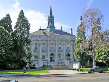
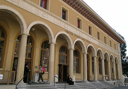
The Landmarks Preservation Ordinance has been in place since 1974. The very first Berkeley designated landmark was Old City Hall. Today, that building still stands but it is neglected, rapidly deteriorating, and threatened. Another building that is threatened today is the nearby Main Post Office. Additionally, there are concerns about impacts of the level of development allowed in the Council approved Downtown Plan on other older historic buildings in that District. What will our Downtown be like if all of the projects currently in the pipeline and the tall buildings that could be built were actually constructed?
Over the years there have been various attempts at weakening the Landmarks Preservation Ordinance, but it has always prevailed until recently. The most serious attempt was in 2006 when the Mayor and Council rewrote the Landmarks Preservation Ordinance and also made it easier to demolish older buildings. With a lot of work at the grassroots level that effort was turned back. Then, in 2010, Measure R shortened the landmark review process which further threatens older structures in the Downtown. And today, new language has been proposed by Planning Staff, that would make it easier to demolish and replace older multi-family structures with new, larger buildings.
What can we do about these problems? First and foremost, this speaker recommends working to obtain voter approval of the Green Downtown and Public Commons Initiative that will appear on the November 2014 ballot. Reinstating the former language of the Landmarks Preservation Ordinance and the adoption of the Historic Overlay language within that Initiative by the voters will provide protection for buildings such as Old City Hall and the Main Post Office and other historic structures that cannot be overridden by the current or future City Councils.
Secondly, we need to be aware of and advocate for recent studies such as the one done by the National Trust for Historic Preservation in May 2014. Titled Older, Smaller, Better it measured how the character of buildings and blocks influences urban vitality. A team of preservationists, economists and architects concerned about sustainability concluded
Based upon statistical analysis of the built fabric of three major American cities, this research finds that established neighborhoods with a mix of older, smaller buildings perform better than districts with larger, newer structures when tested against a range of economics, social and environmental outcome measures.
The three cities they looked at were Washington D.C., Seattle, and San Francisco. Some of the measures they looked at were walkability, the number of locally owned businesses instead of chain stores, job creation, social interaction within a neighborhood, “human-scale” buildings — many of the factors that we relate to talking about neighborhood preservation. They concluded based on measurable outcomes that older and smaller is better.
The final panelist was Shirley Dean, former Mayor who spoke on Revenue Needs.
The answer to the question of how we preserve our neighborhoods, meet our housing needs and provide the revenues to pay for necessary City services is obscured by many complexities — fiscal, social, and physical. Those complexities are further compounded by the lack of data. The core concept here is that fiscal policies shape our city and neighborhoods. What gets funded, determines what happens on our streets. Now, what residents are offered is the repeated mantra that development is the way to pay for the services we want.
Over the 10-year period 2003 to 2013, looking at property tax revenues and business license fees which are the most sensitive to new development, property tax revenues adjusted for changes in the CPI increased around 27%, business license fees increased around 23%. You might say pretty good, but during this time, that increase didn’t change the need for increased taxes, and neighborhoods have become increasingly concerned about livability.
Census data from 2000 and 2010 show an increase in Berkeley’s population of a little less than 9%, around today’s 113,000. The largest population increase came from some 5,600 more people living in “group quarters” in 2010 than in 2000. The number of people living in owner-occupied housing units dropped to 41% in 2010, and those living in rental units rose to 59%. Rents from those housing units increased from a mere $740 to $1,177 per month according to 2005-2007 data. The median value of owner occupied housing about doubled to $731,000 in 2010, with median family income rising to $98,203, a 28% increase. These are all trends that can be reasonably assumed to be continuing. Berkeley is becoming a community of renters, one that is wealthier with poorer or middle-class working families being driven out by rising taxes and housing costs. Berkeley had fewer children under 17 years of age (around 12% in 2010), and is growing older, 62 years and older, (again around 12%). Our City is now predominately white (almost 60%), with fewer African Americans (down from over 25% in the 60s to 10% in 2010), more Asians (about 19% now) and about 11% Hispanic.
Berkeley has what in budget language is known as a “structural deficit”, i.e. spending is greater than income. In each of the 10 years, the City faced just such a deficit and handled it by measures that are a combination of eliminating vacant City positions, raising property taxes and deferring maintenance. By 2014, more than 200 full time equivalent positions had been eliminated, but no career employee ever lost his or her job.
Budget documents show the impact of Berkeley fees and taxes on home owners by using the example of an average 1,900 square foot house. In 2003, that “average” home had an assessed value of about $238,000 and an annual tax bill of $3,500. In 2013, the average 1,900 sq ft home had an assessed value of $363,600 and a tax bill of $5,200 not counting the voter-approved Measure M $30 million street repair bond, or the 25% increase in refuse collection fees. City graphs indicate an almost flat property tax with steadily rising special taxes and fees and bond debt. There are no budget document samples that show all the taxes such as those for the school district which are very high, etc, so the true picture of what that “average” homeowner pays in taxes is a great deal more than what is expressed in official budget documents.
The question of whether renters care about the taxes they vote on always comes up. One answer was clear in November 2004 when student renters were publicly vocal in their opposition to increasing a tax that would cause their cell phone bills to go up. That measure went down, but to be fair so did other tax measures that year. Of course, increased property taxes cause rental costs to go up, but it’s uneven, as what resulted with Prop 13, some units in a building will be held down and other units in that same building will go up if they have been voluntarily vacated in the past, while all units in new buildings will go up. The truth is that renters have no idea how increased taxes affect their rents, and both renters and home owners alike don’t know how their tax money is spent.
In that same 10-year period, the number of UC students increased by 3,188. So, if you’re a student, what did you do? You got lots of roommates to help pay your rent. If you’re a family, you moved to another community. If you’re a developer, you built more multi-family housing with higher rents and you supported politicians that want to make it easier to build more multi-family housing.
This Tuesday, Council discussed raising impact fees on commercial (not retail) developments. Staff said that multi-family development over retail space has become so attractive to developers in Berkeley that coupled with our high fees in comparison to other Bay Area cities, commercial development such as office space has been discouraged. To counter this, they said staff is focusing on building Class A offices to attract high tech into the Downtown. In the end, Council approved “a moderate increase” because of the already high development costs, but skipped over was the reality that whenever UC moves into office space, there is a reduction in property taxes and a total exemption from impact fees. Just how much of the Downtown is already tax exempt? We need to know this information and to understand that more density always equals the need to spend more because we need to provide more services to more people. It doesn’t always equal just more revenue and even if it did, does that amount equal the costs of more fire fighters and their equipment, health workers, mental health counselors, police officers, code enforcement, records clerks, street and sidewalk repair, etc., etc?
Our structural deficit is projected to continue years into the future. Why — is no secret — slow economy, ever-increasing unfunded pension liability (particularly over CalSTRS, the teachers’ retirement fund that is in deep financial problems), increasing health costs, personnel policies that allow city employees to accumulate vacation rather than zero it out annually, a City debt service that has increased from $11 million in 2005 to $13 million in 2013, and decreased income from interest and parking.
What can we do? We start by identifying exactly how we spend our money. Instead of allocating funds by departments, we do it by program. We establish priorities that have resulted from conversations with the community. These are the program actions that will be funded to achieve specific measurable outcomes that will be evaluated. We say who will be held accountable to make those outcomes happen. It doesn’t have to be zero-based budgeting. A certain level of core services could be established, to which other programs would be added that reflect the total of the community’s priorities. We then know what and when to keep, amend, or cut, not make uninformed decisions based on across the board percentages or that some positions were vacant.
In 2005, a group of citizens called BUDGETWATCH called for Program Budgeting, establishing priorities, measuring outcomes and designating accountability. They were ignored. In 2014, a group of students from UCs Goldman School of Public Policy recommended essentially the same thing only they called it “Berkeley Based Budgeting,” with the same end result.
We need to follow-up on these recommendations, and begin the effort to forge a new relationship with our UC neighbor to ensure they pay their fair share for City services. That doesn’t mean we don’t appreciate UC. Of course, we do, the campus is what makes Berkeley the special place that it is, but that shouldn’t stop us from making reasonable arguments and consistently pursuing a solution.
None of this will be easy, but none of it is impossible if neighborhoods work together and lead the effort. If we determine that neighborhoods need more open space, or setbacks from abutting properties, or more street lights, or Mini-Dorm regulations, or whatever, then we must ensure that such programs are included in the budget and that the staff, maintenance and equipment needed to accomplish that goal is funded and that it gets done.
Our purpose is not to stop development, but to manage it. Then, we will reach our goal of preserving our neighborhoods, meeting our housing needs, increasing our tax base, and paying for the services we need.
List of Possible Actions to be Discussed Further Starting at the Next BNC General Meeting:
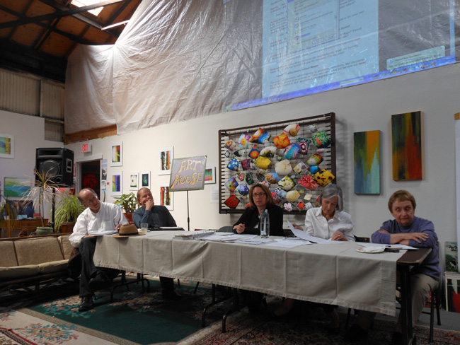
Saturday, July 19, 2014, 10:00 am to Noon
The Art House Gallery, 2905 Shattuck Avenue, Berkeley
-
- Enact a Consistency Ordinance ensuring that the Zoning Ordinance conforms to the General Plan.
- Amend the General Plan to require that density calculations be parcel based.
- Strengthen Landmarks Preservation Ordinance and process to promote historic property designated on State Registry, encourage historic districts and develop design standards for properties near historic properties.
- Adopt design standards to provide for consistent treatment along all transit corridors and ensuring sensitive transitions from higher densities on major arterials at interfaces with R1 — R3 residential districts.
- Developments should be planned to encourage solar installations on rooftops of commercial and residential buildings. Create incentives/mechanisms.
- Mandate greater transparency: Notify all affected property owners and residents of changes to development standards in the same manner as required for zoning reclassifications. Define that “affected properties” include those properties that are adjacent to the properties proposed to be changed. Require that applications for Administrative Use Permits, Use Permits and Variances be in the name of the proposed occupant, not a third party.
- Manage height by enacting a lower height in recognition that density bonuses, mechanicals, architectural details, and the like will add to that height, so that when construction is finished, the anticipated/planned height for the development equals the actual result. Consider the impact on height of mixed use buildings.
- Density cap: start with acknowledging that Berkeley is already a dense community.
- Prohibit projects from coming before the Planning Commission/Zoning Adjustments Board before they are presented to the public.
- Retain the Non-Detriment finding language, but strengthen its application, making it consistent throughout the findings and development standards, providing training to Staff and ZAB Board members. Even though staff will write findings after the decision is made, require ZAB/Council members to articulate their reasoning related to the Non-Detriment requirement when they vote. Improve noticing to impacted areas/neighborhoods so they are aware of the detriment finding.
- Motivate the community — strengthen process for public input and define community aspirations. Facilitate community communication through discussion of issues and attempts to problem solve before issues go to the Zoning Adjustments Board/City Council.
- Have organizations like Berkeley Neighborhoods Council organize zoning/planning round tables, instructing residents on using the Zoning Ordinance and General Plan. Planners should meet with neighbors in the same manner they meet with developers.
- Hold meetings to discuss, disseminate information about and increase understanding of such studies as the National Trust for Historic Preservation’s Older, Better, Smaller and how they relate to Berkeley’s neighborhoods.
- Include discussion of transportation alternatives in considering planning and development issues — potential assets and impacts.
- Advocate for better public transportation service and for alternatives such as shuttles to serve underserved neighborhoods.
- Undertake another comprehensive traffic management plan.
- Retain strong demolition standards.
- Address the need for off street parking in general, but also specifically evaluate the need for the 19 parking spaces on Center St between Milvia and Martin Luther King Jr. Way that are reserved for senior City Staff.
- We need to look at the 2 competing park measures that are on the November ballot. One is a Mello Roos measure that will fund some on-going maintenance plus capital improvement projects in various areas of the City. The other only applies to capital improvements. Parks are important to all neighborhoods.
- We also need to consider taking a position on the Green Downtown and Public Commons Initiative since not one of the proposed development projects have indicated they will return any of the community benefits that were promised to voters in Measure R and there is no way to currently require them to do so.
- Implement Program Budgeting and create a financial plan so that Council Members and the public know exactly how the City’s money is being spent.
- Establish budget priorities through a process that involves the community, Council and staff. Does not have to start from zero. Priorities could be established on top of a core of essential community services. Priority programs must have funding, goals and accountability so that the Council and community can ensure that goals get achieved and to inform when and where cuts, amendments, increases should be made.
- Initiate a study of the impacts of all tax exempt properties, but particularly UC, throughout all of Berkeley
- Establish a neighborhood committee that meets regularly with the Chancellor regarding land use, fees, neighborhood impacts of UC actions.